Haeparang Trail (Gyeongju, Pohang, Yeongdeok sections)
Korean name해파랑길(경주, 포항, 영덕 구간)
Machine-translated from Korean. Show original
The Haeparang Trail is the longest walking travel route in South Korea, totaling 750 km, starting from Oryukdo in Busan. Among them, this is a course that walks the sections of Gyeongju, Pohang, and Yeongdeok. You can visit the Tomb of King Munmu, Gameunsa Temple Site, and Igyeondae located in Gyeongju. It is also a course that includes Yangpo Port, Janggi Eupseong, Malmok Jangseong in Pohang, and the traditional village of Goesi-ri in Yeongdeok. <br><br>
Details
- Tomb of King Munmu
- About 200m off the coast from the land in the waters in front of Bonggil-ri, there is a rocky islet, and this is the underwater tomb of King Munmu (661-681), the 30th king of Silla who achieved the unification of the Three Kingdoms. On the rocky islet with a circumference of 200m, a cross-shaped water channel was carved east-west and north-south, and in the center a small pond-like hollow forms a basin; it is presumed that a large stone 3.6m deep, 2.85m wide, and 0.9m thick was placed 2m underwater and the remains were enshrined beneath it. However, whether the ashes were scattered after cremation or the remains were enshrined directly is still debated among scholars. This large stone is called Daewangam and is designated as a historic site.
- Gameunsa Temple Site, Gyeongju
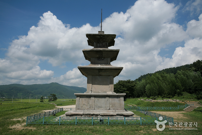
- Gameunsa Temple (感恩寺) was a Silla-era temple: King Munmu, the 30th king of Silla, after accomplishing the great task of unifying the Three Kingdoms, built a temple here to repel Japanese pirate invasions through the power of the Buddha, but he passed away before completing it, and his son King Sinmun, following his will, completed it in 682, the second year after his accession. Before his death, King Munmu left a will saying, "When I die, I wish to become a dragon of the sea and protect the country, so cremate me and bury me in the East Sea," and the place where he was buried in accordance with that will is Daewangam; it is said that, grateful for the father king's grace, the temple was completed and named Gameunsa. Its current appearance is the result of a full-scale excavation survey conducted over two years starting in 1979, through which the building foundation from the time of its founding was exposed and reorganized; in addition, a special structure was revealed in which a symbolic space for the rest of King Munmu, who became a sea dragon, was prepared beneath the main hall, and traces of a passage made toward the east were also uncovered. The two towering three-story stone pagodas are stone pagodas from the early Unified Silla period whose date of construction is certain, built in prefabricated fashion by being made in dozens of parts and assembled, and at a total height of 13.4m they are the largest among Silla three-story stone pagodas.
- Gyeongju Igyeondae
- There are two places where one can meaningfully observe the Daewangam. One is the Igyeondae in front of Daebon Elementary School, and the other is the spot where the monument "My Unforgettable Sea" stands beneath the marker stone called Donghaegu (East Sea Mouth). Igyeondae is the place where King Munmu, who refused a splendid tomb and vowed to become a dragon of the East Sea to protect the country, showed himself transformed into a dragon, and it is a historic place where his son King Sinmun obtained the Manpasikjeok, a precious treasure that cannot be exchanged even for a thousand gold pieces. The name Igyeondae was taken from the phrase "飛龍在天 利見大人" (a flying dragon in the sky, beneficial to see the great man) in the I Ching, and the current building was recently constructed based on the foundation stones revealed during the 1970 excavation survey.
Going down below the Donghaegu marker stone, one can see the monument "My Unforgettable Sea," erected in 1985 by his disciples to honor the anti-Japanese will of Master Uhyeon Go Yu-seop. As if driving a wedge into Japan's high-handed attempt during the Japanese colonial period to justify clear aggression under the name of Nae-Seon Ilche (Japan-Korea Unity), it is all the more meaningful that Go Yu-seop's poem "Daewangam" and the monument "My Unforgettable Sea" are erected side by side at a spot overlooking Daewangam, reflecting on King Munmu's will to defend the country, who had already guarded against Japanese pirate invasions during the Unified Silla period. - Yangpo Port
- Yangpo Port is a fishing port located in Nam-gu, Pohang City, North Gyeongsang Province. Around the port where fishing boats are moored and on the breakwater, many people enjoy fishing. In addition, Yangpo Port has fishing boats that go out regularly, making it a place favored by anglers. The main fish species of Yangpo Port are flatfish, yellowtail, Atka mackerel, and octopus. Around Yangpo Port there are fishing tackle shops, supermarkets, restaurants, and pensions. Moving north from Yangpo Port, Guryongpo Port, Guryongpo Beach, and Homigot Sunrise Plaza appear in order. In addition, moving south, there are several beaches around Gampo in Gyeongju, making linked tourism easy.
- Pohang Janggi Eupseong
- Janggi-myeon in Pohang City is a region adjoining Gampo-eup in Gyeongju City. On the East Sea coastal side there are travel attractions such as Yangpo Port and Daejin Beach, and if you continue north along the coastal road, you reach Guryongpo Port and Janggi Cape. Janggi Eupseong (historic site), located on the eastern slope of Dongaksan (252.5m) in Eupnae-ri, Janggi-myeon, suffered hardships during the Japanese colonial period. During the Japanese colonial period, all government office buildings within this town fortress were destroyed by the Japanese, and only the hyanggyo is being restored and maintained by the residents of this area, while most of the castle walls buried in weeds have collapsed.
This fortress, along with other town fortresses that guarded the East Coast, possessed characteristics as an important military base given the geographical configuration of the Janggi region, and examining various records suggests that Janggi Eupseong was an old fortress from before the Goryeo period. Meanwhile, this place was treated as a remote area and served as a place of exile, where Uam Song Si-yeol and Dasan Jeong Yak-yong were exiled here. In particular, Juknim Seowon was built to honor Song Si-yeol, and this region became a village of learning, and it can be said to be a place that fulfilled its role as a military stronghold responsible for a part of national defense, rather than a place with political, economic, and social characteristics. Yeongil Janggi Eupseong was renamed to Pohang Janggi Eupseong. - Guryongpo Malmokjangseong Trail
- The Guryongpo Malmokjangseong Trail was created as a walking path in 2009 when the Guryongpo Township Office excavated about 4 km of the Seokjangteo site. A two-story observatory was installed at the summit at 205 m above sea level, allowing a panoramic view of the beautiful coastal village of Guryongpo and the Homi Peninsula ridge of the Taebaek Mountains at a glance. Near the summit, azaleas and Gucheolcho are planted to provide tourists with more diverse things to see. The stone wall of Malmokjang refers to the stone fence used for raising horses. The exact time of construction is unknown, but looking at various records such as the Samguk Yusa, the history of Malmokjang is estimated to be about 1,400 years old. Originally it was built about 8 km long from Guryongpo to Namgu Heunghwan-ri, but currently 5.6 km remains. A lower-ranking official of the 6th rank managed the horse ranch, and it is said that the Mokjagun lived here and did chores such as cleaning manure.
- Goesiri Traditional Village
- Goesiri Traditional Village, where more than 30 old houses that are about 200 years old are lined up, is a clan village of the Yeongyang Nam clan, a village in the shape of the character 八 (palja) that has enjoyed settlement for about 400 years. In front of the village, the Yeonghae Plain spreads out widely, and because it is said that there was a lake (hoji) in the past, it came to be called Hojigol, and it is also called Hojimaeul. And the current village name Goesiri was given when a Chinese envoy, who was close with Master Mokeun Yi Saek, visited the village in the 8th year of King Gongmin of Goryeo and said the village's shape resembled Hojichon in the Sugu Pungmyeon of Goesiri, so it was called Goesiri. With old houses that are hard to find even in the province, the Nam clan Goesipa Jongtaek and six other old houses are designated and managed as cultural properties.
Visitor reviews 0
Videos of this place
Gyeongju-si travel resources
All guides →- e-book